Before the Harbour Wall: How Coastal Settlements Made a Working Edge
How coastal settlements made a working edge through practical choices about harbor walls, landings, and repairs—and what those decisions reveal today.
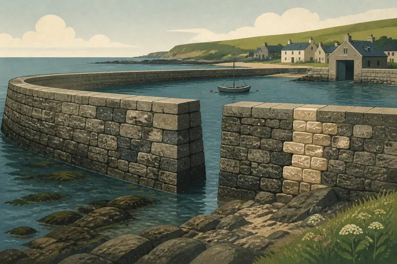
The common mistake in reading an old harbor is to treat its wall as the whole story. That costs us a view of how builders chose materials, routed water, and judged where a barrier would hold; those decisions reveal the settlement’s practical knowledge of its coast.
Reading the harbor wall
A harbor wall was an answer to local conditions, not a standard feature copied from one coast to another. Its alignment might follow a headland, shelter a basin, or protect a vulnerable stretch of shore. Builders had to work with the seabed, the force and direction of waves, available materials, and the labor they could organize.
Stonework can reveal choices about construction. Large blocks may form a robust outer face, while smaller stones fill spaces behind it. Timber could be used where it was available and suited to the task. Later repairs may differ visibly from older sections, leaving a record of changing methods and resources.
These clues deserve care. A wall’s appearance alone cannot establish when it was built, who paid for it, or what technical knowledge its builders possessed. Local histories, maps, archival descriptions, and conservation records can help distinguish evidence from a plausible guess.
Water and foundation
Before a wall could stand, its builders needed a foundation that could meet the ground beneath the water. On a rocky shore, natural stone might offer a firm base. On softer ground, builders faced a different problem: a structure had to resist movement and erosion without relying on a solid rock platform.
The wall’s shape also had to respond to water. A sloping face can meet waves differently from a vertical one, and openings may allow water to pass or provide access. But a feature’s purpose cannot be read from shape alone; later alterations, changing shoreline conditions, and local construction practice all matter.
Say a town has a low stone wall with a gap near the mouth of its harbor. If an old map shows a channel running through that gap and a local record describes boats entering there, the evidence supports an access route. If no such record survives, the gap remains a clue, not a settled explanation.
Materials and maintenance
Building material often reflected what a settlement could obtain and work. Nearby stone reduced the need to move heavy loads far; timber could serve where suitable wood and skilled carpenters were available. Reused masonry might point to rebuilding or material scarcity, though it does not by itself explain why earlier structures were dismantled.
Maintenance shaped a wall as much as its original construction did. Storm damage, shifting stones, and wear could prompt repairs that changed the surface or profile. A seam between masonry styles may mark a repair campaign, but dating it requires supporting evidence such as plans, records, or documented conservation work.
For a careful first look, note the wall’s material, the pattern of repairs, and the parts exposed to weather. Compare those observations with local heritage records before assigning a date or cause. If the site is protected, do not move stones, scrape surfaces, or climb unstable sections.
What can the wall tell us?
How can I estimate a harbor wall’s age?
Start with local maps, historic photographs, harbor records, and heritage listings, then compare them with visible changes in the masonry. Construction details can suggest a period, but a qualified local historian or conservation professional is better placed to assess conflicting clues.
Why do harbor walls have different shapes?
Shape reflects the shoreline, water exposure, intended harbor layout, available materials, and construction practice. A curved, sloped, or stepped section can offer a clue to those conditions, but it does not prove a specific design purpose by itself.
What should I record during a visit?
Note the wall’s location, visible materials, openings, repair seams, and relationship to nearby landforms. Follow posted access rules, keep clear of unstable masonry, and use photographs or public records rather than disturbing the structure.
Who can help interpret a historic harbor wall?
Local archives, maritime museums, heritage organizations, and municipal planning or conservation offices may hold relevant records. For structural concerns or proposed repairs, consult a qualified conservation professional or engineer familiar with historic masonry.
From observation to decision
A short field record can help keep interpretation grounded. For each feature, write what you can directly see, what evidence might explain it, and what remains uncertain. Use the following checks to decide what to investigate next:
- Check whether a map or photograph shows the wall in the same location; if it does, compare its earlier outline with the present one, and if it does not, look for another dated local record.
- Check whether repair seams differ in stone size or mortar appearance; if they do, seek conservation records before assigning a date, and if they do not, describe the masonry without claiming it is all from one period.
- Check whether an opening aligns with a documented channel or route; if it does, record that connection as supported, and if it does not, leave the opening’s purpose unresolved.
- Check whether the wall sits on exposed rock or softer shore ground; if the base is visible and stable, describe the observed contact, and if it is submerged or obscured, avoid guessing about the foundation.
- Check posted signs and local access notices before approaching the wall; if access is permitted, stay on public paths, and if it is restricted or unclear, keep away and ask the harbor authority or land manager.
- Check for loose stones, fresh cracking, or sections under repair; if any appear, keep clear and report a concern to the responsible local authority, and if none are visible, still avoid climbing or touching the masonry.
Imagine a visitor sees a curved stone wall, a narrow opening, and a newer-looking patch. The visitor records those observations, then checks a public harbor map and finds the opening marked as a channel; a local conservation note identifies the patch as a later repair. The resulting account can say that the gap served a documented route and that part of the wall was repaired later, while leaving the wall’s original construction date open until another source supports it.
How coastal settlements made a working edge is visible not only in the wall’s outline but in its foundation, materials, repairs, and relationship to water. Reading those features alongside local records gives a more dependable account than assigning a purpose or date from appearance alone. The most useful habit is to keep observation and interpretation separate: describe what remains, then make each historical claim answerable to evidence.