Why Tidal Flats Change the Shape of a Coast
Learn how to read tidal flats through slope, waterline, channels, and sediment, so you can describe changing shore conditions more clearly and accurately.
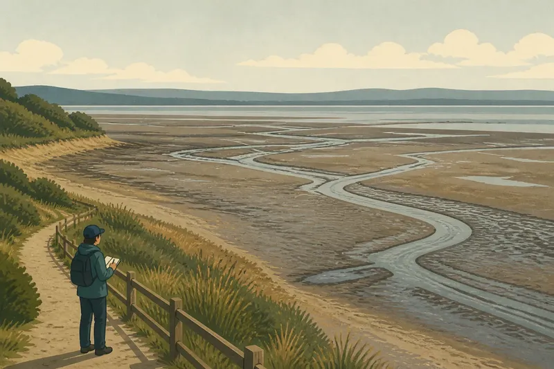
The common mistake on a tidal flat is to treat the visible waterline as the coast’s fixed edge. That can make a visitor misread the flat’s exposed area and overlook how its slope, drainage channels, and sediment shape what appears at a given tide stage. Tidal flats change the shape of a coast by making water and sediment part of the same shifting surface.
Read the slope
From a safe, permitted viewing place, look across the flat before focusing on details. A tidal flat is a broad area of sediment that the tide covers and uncovers. Its surface often descends gradually toward deeper water, so a change in water level can move the visible boundary a long way across the shore.
Notice how the slope meets the land behind it. Salt-tolerant plants, a bank, or a change in sediment may mark the upper edge. Farther out, the surface may look smooth, ribbed, or divided by narrow channels. These features describe the flat’s shape more reliably than the waterline alone.
Appearance does not reveal depth or firmness. Mud, sand, and mixed sediment can look similar from a distance, while channels and soft patches may be hard to see. Stay on established access routes or firm ground, and follow posted local guidance.
Track the waterline
The place where water meets exposed sediment is a temporary boundary. As the tide rises, water advances across the shallow slope; as it falls, more of the flat is exposed. Wind, waves, river flow, and seabed shape can make the line uneven.
For a useful comparison, record the viewing place, the tide stage if known, and visible features such as channels and the upper edge. A photograph can supplement those notes, but label its location and conditions rather than presenting it as a map of the shore.
Say a visitor wants to compare two views from a marked public path. In this invented example, the first visit is at a falling tide, with water still covering the outer flat and a narrow creek visible near the center. On the second visit, at a rising tide, water has reached the outer edge of the exposed sediment, while the creek’s mouth remains visible and the upper boundary beside the grass has not changed. The visitor writes down those observations and identifies tide stage as a likely reason for the difference in exposed area; the record describes changing coverage, not evidence that the coast moved overnight.
Follow channels and ridges
Small channels carry water across the flat, often joining larger runs toward a creek or tidal inlet. Their branching forms can suggest how water drains as the tide retreats, but one view cannot establish how every channel behaves at every stage.
Low ridges, shallow hollows, and rippled patches also shape the surface. They may reflect the movement of water and sediment, yet their appearance can shift with tides and weather. Treat them as signs of recent or recurring movement, not as permanent lines like a road or seawall.
Scale matters. A channel that looks continuous from a lookout may divide or disappear behind a ridge at ground level. A map or aerial image can add context, but check its date and tide conditions before comparing it with what you see.
Compare sediment and edges
Color and texture can vary across an exposed flat. Fine, dark mud may collect in sheltered places, while sandier patches can look lighter or more rippled. These are visual tendencies, not a dependable way to identify what lies beneath the surface.
At the landward edge, vegetation or a sharper bank may mark where the flat meets another coastal environment. The seaward transition depends heavily on the tide and may be hard to define. Sometimes a gradual change in sediment says more than a crisp boundary.
Local names, harbor maps, and coastal interpretation signs connect visible features with shared knowledge of a place. A sign may identify an inlet or creek, while residents may use a name tied to a familiar route. Treat labels as descriptions of selected features, not as claims that the surrounding water and sediment stay fixed.
Questions about tidal flats?
Why does the waterline travel so far?
A shallow gradient means the seabed changes height gradually over a broad horizontal distance. As the tide changes, the boundary between water and exposed sediment can shift across much of the flat.
Do channels stay in the same place?
Some channels recur because tidal water follows familiar routes. Their edges and smaller branches may still change as sediment moves, so describe what is visible rather than assuming every channel is fixed.
Can a photograph show the whole flat?
A photograph captures one viewpoint under particular conditions. It can show a useful arrangement of features, but cannot establish the flat’s full extent, firmness, or appearance at another tide stage.
What should I record on two visits?
Use the same safe viewpoint and note the date, tide stage if available, and features such as channels and the upper edge. Those details help distinguish a change in exposure from a change in the landform.
Describe conditions precisely
When writing about a tidal flat, name the viewpoint and conditions: “exposed at a falling tide from the marked path” is more precise than calling the whole coast bare or flooded. Follow local access notices and shoreline guidance, since conditions and rules vary by place.
- Check whether the viewing spot is an established public route; if it is, observe from there, but if access is restricted, use a permitted viewpoint.
- Check the tide stage on a local tide table; if it is available, record the stated stage, but if it is not, describe the visible waterline without guessing.
- Check whether channels are visible; if they are, note their direction and branches, but if they are obscured, leave their course undescribed.
- Check the upper edge for vegetation or a bank; if either is visible, record that feature, but if neither is clear, avoid assigning a precise boundary.
- Check the date and conditions attached to a map or aerial image; if they are known, compare cautiously, but if they are missing, use the image only as general context.
- Check for posted access or shoreline guidance; if notices apply, follow them, but if their meaning is unclear, ask the responsible local authority before entering the flat.
Reading a tidal flat means attending to slope, waterline, channels, sediment, and the landward edge in relation to one another. The phrase why tidal flats change the shape of a coast points to a useful distinction: the shoreline is not merely a boundary but a broad surface whose changing exposure makes its form visible.
Before leaving, look back from the same safe spot and note what remains legible as the water shifts: perhaps a creek’s direction, a ridge, or the meeting of mud and vegetation. Those recurring features help describe the coast without mistaking one tide’s outline for its lasting shape.